
Google Maps User Spots Mysterious Satellite Zooming Over Texas, possibly a Starlink Satellite
In an unexpected twist of digital sleuthing, a Reddit user recently stumbled upon a curious sight while casually exploring Google Maps’ satellite imagery. The user, browsing the map’s satellite image layer, discovered what appears to be a fast-moving satellite streaking across the skies above northern Texas — and speculation is swirling that it might be a Starlink satellite from Elon Musk’s SpaceX fleet.
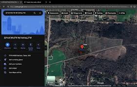
Figure 1. Google Maps.
According to details visible in Google Earth, the image was taken on November 30 by an Airbus satellite, which captured a striking afterimage of the object in motion — red, green, and blue streaks — the result of how satellite sensors process imagery using RGB color bands. Figure 1 shows Google Maps.
What’s fueling the buzz? The object’s design. Experts and amateur analysts point to the presence of dual solar panel arrays, a hallmark of SpaceX’s Starlink satellites [1]. These low-Earth orbit satellites travel at dizzying speeds of around 17,000 mph, and while they’re difficult to spot, they do occasionally get captured in high-resolution satellite photography — albeit rarely.
This isn’t the first time a Starlink satellite has been unexpectedly caught on camera. In August of last year, BlackSky snapped a clear shot of a Starlink V2 mini satellite flying over the Pacific Ocean near Alaska, further proving these high-tech crafts aren’t always as invisible as we think.
Still, there’s room for doubt. While some believe the satellite is definitely part of Starlink’s growing constellation, others, including one satellite expert, suggest it could be a Chinese satellite, possibly the Ziyuan-3-2, which also shares visual similarities and orbits at comparable altitudes.
Interestingly, another Reddit user came forward with more data showing the satellite passed over the same region on the exact date. The consistency only adds fuel to the mystery.
As of now, SpaceX has not responded to requests for comment, and Google, Airbus, and Maxar Intelligence have remained silent as well. But the question remains: Are we beginning to see more Starlink satellites unintentionally featured in satellite imagery? And if so, what does this mean for the future of Earth observation and commercial satellite networks?
One thing’s for sure — this unexpected find has sparked fascination across the online space and astronomy communities. With satellite constellations like Starlink continuing to grow, moments like these may become more common. Until then, we’ll be keeping an eye on the skies — and our maps.
References:
- https://www.digitalinformationworld.com/2025/04/google-maps-user-spots-mysterious.html
Cite this article:
Keerthana S (2025), Google Maps User Spots Mysterious Satellite Zooming Over Texas, possibly a Starlink Satellite, AnaTechMaz, pp.262
Recent Post
-

OpenAI May Soon Allow You To ‘Sign in with ChatGPT’ on Third-Party Apps
OpenAI is considering introducing a "Sign in with ChatGPT".....
-

Microsoft Begins Testing Copilot for Gaming in The Xbox App on iOS and Android
Microsoft announced on Wednesday the beta rollout of its Copilot......
-

Nvidia Anticipates Billions in Revenue Loss Due to H20 Chip Licensing Mandates
As Nvidia announced its earnings for the first quarter of fiscal......
-

Apple Reportedly Set to Launch AI-Powered Battery-Saving Feature in Ios 19 For Iphones
Speculation is heating up around the upcoming iOS 19 update.....
-

Android 16 Rolls Out Enhanced Security and Intelligent Anti-Theft Features
Android 16, the upcoming major update for Android devices, is......
-

Children’s Websites Riddled with Tracking and Inappropriate Ads, Study Finds
At first glance, websites designed for children appear safe and......
-
Google Maps User Spots Mysterious Satellite Zooming Over Texas, possibly a Starlink Satellite
In an unexpected twist of digital sleuthing, a Reddit user recently......

Trump Mobile Unveils $499 Android Smartphone with an Unlimited Service Plan Priced At $47.45 Per Month
The Trump Organization has...
How Your Android Phone Is Capable of Detecting Earthquakes
Your Android phone has a hidden life-saving feature you may not know about: it can detect earthquakes and send ...

ElevenLabs Launches Mobile Text-to-Speech App—No Browser Required
ElevenLabs has introduced a new mobile app that allows users to...
-

Research Links Addictive Tech Habits in Teens to Greater Mental Health Risks
Adolescents who become deeply attached to mobile phones,...
-

Researchers Crack Security of eSIM Chips Found in Billions of Devices
A newly discovered vulnerability in widely used eSIM chips could...
-

Rugged Adventure Phone Delivers Sharper Visuals with Built-In Projector
Portable projectors can deliver movies to the campsite or support......
-

What Gibberish Reveals About ChatGPT’s Grasp of Language
By now, most of us have tried to stump a chatbot — asking if it has feelings, testing......
-

How to Disable AI Features in Windows for a More Peaceful Experience
Microsoft—like most major tech companies—is packing artificial......