
New AI Technique Can Improve Wildfire Forecasts
A new technique developed by the National Center for Atmospheric Research (NCAR) uses artificial intelligence to efficiently update the vegetation maps that are relied on by wildfire computer models to accurately predict fire behavior and spread.
In a recent study, scientists demonstrated the method using the 2020 East Troublesome Fire in Colorado, which burned through land that was mischaracterized in fuel inventories as being healthy forest. In fact the fire, which grew explosively, scorched a landscape that had recently been ravaged by pine beetles and windstorms, leaving significant swaths of dead and downed timber. [1]
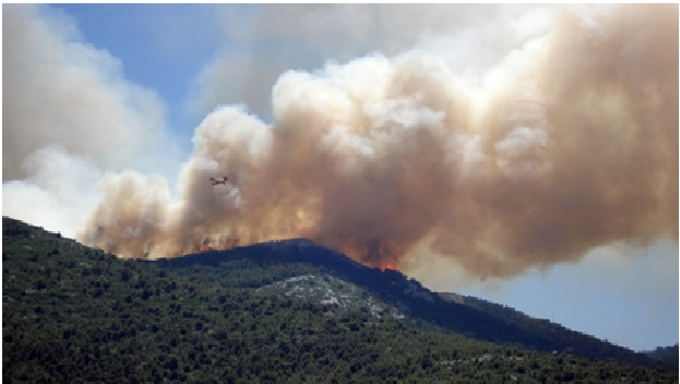
Figure 1. New AI Technique Can Improve Wildfire Forecasts
Figure 1 shows the research team compared simulations of the fire generated by a state-of-the-art wildfire behavior model developed at NCAR using both the standard fuel inventory for the area and one that was updated with artificial intelligence (AI)."One of our main challenges in wildfire modeling has been to get accurate input, including fuel data," said NCAR scientist and lead author Amy DeCastro. [2]
The LANDFIRE Dataset
The best fuel dataset is produced by LANDFIRE, which is a federal program that produces geospatial datasets that contain information on wildfire fuels. To create the wildfire fuel datasets, experts need a lot of satellite imagery, landscape simulation, and survey information. Because of the large amount of required data, it takes a long time to update the datasets. At the same time, the available fuels in an area can change quickly.
Sentinel-1 provides data around surface texture, which can be used to identify vegetation type. Sentinel-2 provides data that can be used to infer the plant’s health from its greeness. This satellite data was fed into a machine learning model that was trained on the U.S. Forest Service’s Insect and Disease Detection Survey, which is conducted annually to estimate tree mortality from the air. [3]
Testing process
Next, the researchers wanted to see how the modified inventory would influence wildfire forecast simulations, so they utilized WRF-Fire, which NCAR built to simulate wildfire behavior.
The East Troublesome Fire was simulated using the unadjusted LANDFIRE fuel data by applying WRF-Fire to it, resulting in an underestimate of burned area. When the ML model was run with the updated wildfire forecast dataset, on the other hand, it predicted this burned area with far more precision. It assumed that dead and down timber would aid in fire spread.
The goal of this machine-learning approach is to modify current fuel maps at the moment, but it may eventually lead to the continuous production and updating of fuel maps. [4]
References:
- https://icymi.in/article/scientists-use-ai-to-update-data-vegetation-maps-for-improved-wildfire-forecasts
- https://www.sciencedaily.com/releases/2022/05/220531102713.htm
- https://www.unite.ai/new-ai-technique-can-improve-wildfire-forecasts/
- https://dataconomy.com/2022/06/ml-model-improves-wildfire-forecast/
Cite this article:
Thanusri swetha J (2022), New AI Technique Can Improve Wildfire Forecasts, AnaTechMaz, pp. 98
Recent Post
-

Startups Apply Artificial Intelligence to Supply Chain Disruptions
A series of unpredictable situations has disarranged the global supply chains...
-

Whale images used for artificial intelligence research
A new dataset featuring hundreds of satellite images of whales has...
-

LEGO-like Artificial Intelligence Chip
Imagine a more sustainable future, where cellphones, smartwatches, and other...
-
Using artificial intelligence to predict life-threatening bacterial disease in dogs
Using artificial intelligence to predict life-threatening bacterial disease in dogs...
-
Artificial Materials Made Transparent or Completely Invisible Using Revolutionary Technology
A team of scientists from the University of Rostock has devised a revolutionary...
-

Calculating the 'fingerprints' of molecules with artificial intelligence
"Macromolecules but also quantum dots, which often consist of thousands...
-

Google Engineer Thinks an AI Has Become Sentient
Google has seen a huge turmoil in the company after a senior software...
-
New AI Technique Can Improve Wildfire Forecasts
A new technique developed by the National Center for Atmospheric Research (NCAR)...
-

New AI Technique Can Improve Wildfire Forecasts
Small autonomous mobile robots, such as drones, rovers, and legged robots...
-

Using AI to detect cancer from patient data securely
A new way of using artificial intelligence to predict cancer from patient data without...
-

Using AI to detect cancer from patient data securely
Image processing is the method of manipulating an image to either enhance...
-

The Artificial Eye Technology: Looking to the Future
Artificial Eye technology is a visual prosthetic system. It is used for replacing...
-

The Development of Artificial Neurons on Silicon Chips
Artificial neurons on silicon chips that behave just like the real thing have...
-

The Artificial Cultivated Lab-Grown Meat
Cultivated meat, also known as cultured meat, is genuine animal meat...
-

A Micro Sized Artificial Cilia to Control Fluids
Cornell researchers have now designed a micro-sized artificial cilial system...